Do any of u guys have a general idea of when they will start contr flow. I want to leave before that starts. Cannot leave now because I have not been released from work.
I see the ensembles keep shifting west. If i remember correctly did someone say that some times they over compensate a shift and may shift back in the opposite direction? Just trying to see if that is correct or not. Thanks
Well, once again we'll be watching the 00z runs tonight, but by tomorrow, I think we'll watching live storm movement rather than analyzing models. It's getting close to nowcasting time.
I'm in that mode now. I'm 75% done with my preps and am now just watching to see which damn model is right.
Do any of u guys have a general idea of when they will start contr flow. I want to leave before that starts. Cannot leave now because I have not been released from work.
Hey MrJamie..I found out the answer to our question. A co-workers aunt works for the Causeway. When Contra Flow starts, bridge remains open both ways with no tolls.
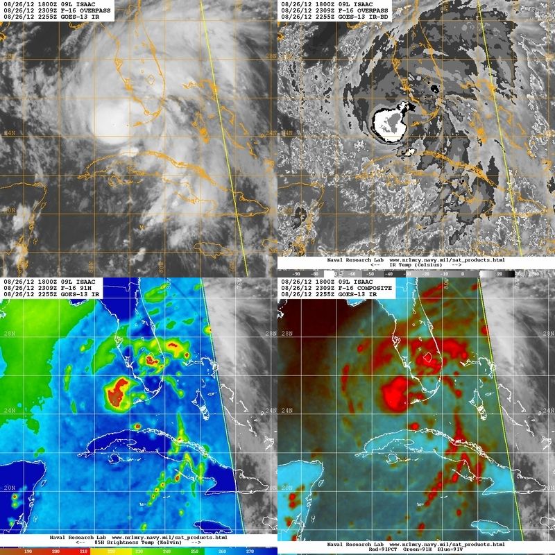
that northerly component is the MLC. The LLC is still well to the south. M/W imagery suggests possibly a new LLC may be trying to develop under the MLC like I mentioned earlier.
Buying or Selling Real Estate?--->scottguidry.com United Real Estate Partners - New Orleans / North Shore Scott Guidry, Realtor, ABR, AHWD, AWREP, C2EX Click HERE To Download My FREE MLS Touch App! NWS COOP ID: 16-7425-08 CoCoRaHs ID: LA-TG-23
mrjamie
GCWX Supporter Vice President | Chief Consultant
Hey MrJamie..I found out the answer to our question. A co-workers aunt works for the Causeway. When Contra Flow starts, bridge remains open both ways with no tolls.
Thanks
GCWX Vice President | Chief Consultant CoCoRaHs Station: LA-ST-8
Find it hard to take this storm seriously when it looks so ragged on radar. I know it has all night and all day to get it together but just saying that it really does look like a big ole thunderstorm, although I know it is not.
Do any of u guys have a general idea of when they will start contr flow. I want to leave before that starts. Cannot leave now because I have not been released from work.
The preparedness guide says 30 hours before tropical storm force winds are expected.
Phase III - 30 Hours before onset of tropical storm winds. Includes areas on the East Bank of the Mississippi River in the New Orleans Metropolitan Area which are within levee protection system but remain vulnerable to a slow-moving Category 3 or any Category 4 or 5 storm. These areas are depicted in YELLOW on the Evacuation Map. During Phase III, certain routes will be directed and the Contraflow Plan implemented.
Nola.com is talking about the possibility of a "compressed contraflow"
SKYSUMMIT
Administrator President | Director of Operations
Buying or Selling Real Estate?--->scottguidry.com United Real Estate Partners - New Orleans / North Shore Scott Guidry, Realtor, ABR, AHWD, AWREP, C2EX Click HERE To Download My FREE MLS Touch App! NWS COOP ID: 16-7425-08 CoCoRaHs ID: LA-TG-23
Shoutbox
northshoreelise: not on the 12z...
Oct 10, 2024 12:15:21 GMT -6
lencast: Really would appreciate it. Thank you, Lena
Sept 27, 2024 5:20:46 GMT -6
lencast: I am in Jacksonville, and trying to drive back to New Orleans. Does anyone here know if the I-10 is passable in Lake City and Tallahassee.
Sept 27, 2024 5:19:03 GMT -6
tcane: This sure looks like it dies quickly. maybe falling apart before metro New Orleans? Just looking at the lat dozen posts and images here.
Sept 10, 2024 11:26:27 GMT -6
rebekahb-Metairie: Looks like it but I wait for the better trained eyes on the forum to respond.
Sept 9, 2024 18:52:32 GMT -6
SKYSUMMIT: Oh sorry guys! I didn't eve see these new messages down here lol
Jul 26, 2024 13:14:47 GMT -6
jenniqtip: Just as soon as* sry fat finger
Jul 7, 2024 12:53:35 GMT -6
jenniqtip: I donate every year. 😀ju sry as soon as the first area of interest pops up!! I rarely post though so the tag isn’t necessary. Just know I appreciate everything you do!!
Jul 7, 2024 12:53:12 GMT -6
larcat: SKYSUMMIT You can slap one on me
Jul 7, 2024 12:12:03 GMT -6
SKYSUMMIT: Thanks laismyhome ! Also, if there is anyone who has donated that has not been given the Supporter tag, please let us know.
Jul 7, 2024 4:00:50 GMT -6
laismyhome: Here's a friendly reminder to go make a donation to support this forum that is so full of valuable reliable info. Link to donate is on homepage
Jul 2, 2024 9:55:24 GMT -6
Deleted: Ernesto gonna mog hard. I'm voting Alberto, Ernesto, Rafael and Deshawn
Apr 1, 2024 19:15:21 GMT -6
SKYSUMMIT: ShanaBanana Yes...just click the link and then send a PM to either TIgergirl or myself. I can then shoot her a text letting her know and I'll add your supporter tag. THANK YOU!!!!
Sept 23, 2023 16:08:37 GMT -6
ShanaBanana: At the risk of this being a dumb question. In order to donate, do I follow the instructions when I click “donate”, and then message tigergirl? I see people comment here that they donated, so I wasn’t sure if that had changed.
Sept 20, 2023 10:54:40 GMT -6
SKYSUMMIT: Great to have you back!
Sept 11, 2023 12:20:30 GMT -6
virginialee: Hi Skysummit: I was part of this back at the beginning. So happy to be back.
Sept 8, 2023 5:08:12 GMT -6
SKYSUMMIT: Thanks to everyone who has recently donated! If I missed anyone and you still need a Supporter Tag, let me know.
Sept 7, 2023 13:20:10 GMT -6
akeller11: Just donated
Sept 6, 2023 11:11:36 GMT -6
SKYSUMMIT: Thanks guys and gals! You're very much appreciated!
Aug 30, 2023 11:48:38 GMT -6