Buying or Selling Real Estate?--->scottguidry.com United Real Estate Partners - New Orleans / North Shore Scott Guidry, Realtor, ABR, AHWD, AWREP, C2EX Click HERE To Download My FREE MLS Touch App! NWS COOP ID: 16-7425-08 CoCoRaHs ID: LA-TG-23
SKYSUMMIT
Administrator President | Director of Operations
Severe Thunderstorm Warning National Weather Service New Orleans LA 141 PM CST Wed Feb 5 2020
The National Weather Service in New Orleans has issued a
* Severe Thunderstorm Warning for... Northeastern Orleans Parish in southeastern Louisiana... Southeastern St. Tammany Parish in southeastern Louisiana... Southwestern Hancock County in southern Mississippi...
* Until 215 PM CST.
* At 141 PM CST, a severe thunderstorm was located near East New Orleans, moving northeast at 45 mph.
HAZARD...60 mph wind gusts and penny size hail.
SOURCE...Radar indicated.
IMPACT...Expect damage to roofs, siding, and trees.
* Locations impacted include... Slidell, East New Orleans, Lake Catherine, Pearlington and Stennis Space Center.
PRECAUTIONARY/PREPAREDNESS ACTIONS...
Prepare immediately for large hail and damaging winds. People outside should move immediately to shelter inside a strong building. Stay away from windows.
To report severe weather, contact your nearest law enforcement agency. They will send your report to the National Weather Service office in New Orleans.
&&
Buying or Selling Real Estate?--->scottguidry.com United Real Estate Partners - New Orleans / North Shore Scott Guidry, Realtor, ABR, AHWD, AWREP, C2EX Click HERE To Download My FREE MLS Touch App! NWS COOP ID: 16-7425-08 CoCoRaHs ID: LA-TG-23
SKYSUMMIT
Administrator President | Director of Operations
Severe Thunderstorm Warning National Weather Service New Orleans LA 141 PM CST Wed Feb 5 2020
The National Weather Service in New Orleans has issued a
* Severe Thunderstorm Warning for... Northeastern Orleans Parish in southeastern Louisiana... Southeastern St. Tammany Parish in southeastern Louisiana... Southwestern Hancock County in southern Mississippi...
* Until 215 PM CST.
* At 141 PM CST, a severe thunderstorm was located near East New Orleans, moving northeast at 45 mph.
HAZARD...60 mph wind gusts and penny size hail.
SOURCE...Radar indicated.
IMPACT...Expect damage to roofs, siding, and trees.
* Locations impacted include... Slidell, East New Orleans, Lake Catherine, Pearlington and Stennis Space Center.
PRECAUTIONARY/PREPAREDNESS ACTIONS...
Prepare immediately for large hail and damaging winds. People outside should move immediately to shelter inside a strong building. Stay away from windows.
To report severe weather, contact your nearest law enforcement agency. They will send your report to the National Weather Service office in New Orleans.
Buying or Selling Real Estate?--->scottguidry.com United Real Estate Partners - New Orleans / North Shore Scott Guidry, Realtor, ABR, AHWD, AWREP, C2EX Click HERE To Download My FREE MLS Touch App! NWS COOP ID: 16-7425-08 CoCoRaHs ID: LA-TG-23
SKYSUMMIT
Administrator President | Director of Operations
Severe Thunderstorm Warning National Weather Service Lake Charles LA 146 PM CST Wed Feb 5 2020
The National Weather Service in Lake Charles has issued a
* Severe Thunderstorm Warning for... Southeastern Lafayette Parish in south central Louisiana... Northwestern Iberia Parish in south central Louisiana... Northeastern Vermilion Parish in southwestern Louisiana... Northwestern St. Martin Parish in south central Louisiana... Eastern St. Landry Parish in central Louisiana...
* Until 245 PM CST.
* At 145 PM CST, a severe thunderstorm was located near Maurice, or 8 miles northeast of Abbeville, moving northeast at 60 mph.
HAZARD...60 mph wind gusts and quarter size hail.
SOURCE...Radar indicated.
IMPACT...Hail damage to vehicles is expected. Expect wind damage to roofs, siding, and trees.
* Locations impacted include... Lafayette, Abbeville, Catahoula, Breaux Bridge, St. Martinville, Broussard, Youngsville, Erath, Henderson, Maurice, Cade, Butte La Rose, Cecilia, Lake Pelba, Atchafalaya National Wildlife Refuge, Jefferson Island, Coteau, Parks and Milton.
This includes Interstate 10 in Louisiana between mile markers 106 and 126.
PRECAUTIONARY/PREPAREDNESS ACTIONS...
A Tornado Watch remains in effect until 600 PM CST for central Louisiana.
For your protection move to an interior room on the lowest floor of a building.
&&
Buying or Selling Real Estate?--->scottguidry.com United Real Estate Partners - New Orleans / North Shore Scott Guidry, Realtor, ABR, AHWD, AWREP, C2EX Click HERE To Download My FREE MLS Touch App! NWS COOP ID: 16-7425-08 CoCoRaHs ID: LA-TG-23
SKYSUMMIT
Administrator President | Director of Operations
NEW Orleans [Orleans Co, LA] EMERGENCY MNGR reports TSTM WND DMG at 1:00 PM CST -- EM REPORTED DAMAGE TO SCAFFOLDING DAMAGE IN CENTRAL BUSINESS DISTRICT, NEW ORLEANS,LA IN ORLEANS PARISH.
Buying or Selling Real Estate?--->scottguidry.com United Real Estate Partners - New Orleans / North Shore Scott Guidry, Realtor, ABR, AHWD, AWREP, C2EX Click HERE To Download My FREE MLS Touch App! NWS COOP ID: 16-7425-08 CoCoRaHs ID: LA-TG-23
NEW Orleans [Orleans Co, LA] EMERGENCY MNGR reports TSTM WND DMG at 1:00 PM CST -- EM REPORTED DAMAGE TO SCAFFOLDING DAMAGE IN CENTRAL BUSINESS DISTRICT, NEW ORLEANS,LA IN ORLEANS PARISH.
GCWX Board Member Spotter Network Trained Emergency Medical Technician 911 Emergency Operator
SKYSUMMIT
Administrator President | Director of Operations
NEW Orleans [Orleans Co, LA] EMERGENCY MNGR reports TSTM WND DMG at 1:00 PM CST -- EM REPORTED DAMAGE TO SCAFFOLDING DAMAGE IN CENTRAL BUSINESS DISTRICT, NEW ORLEANS,LA IN ORLEANS PARISH.
Oh dang....if you can, share a couple.
Buying or Selling Real Estate?--->scottguidry.com United Real Estate Partners - New Orleans / North Shore Scott Guidry, Realtor, ABR, AHWD, AWREP, C2EX Click HERE To Download My FREE MLS Touch App! NWS COOP ID: 16-7425-08 CoCoRaHs ID: LA-TG-23
Seen some pictures, it's the construction site at the World Trade Center. Several vehicles are stuck under the collapsed scaffolding there.
Oh dang....if you can, share a couple.
I was at lunch in the CBD when that rolled through, the wind and rain was insane for about 5 minutes. My coworkers said that from the 10th floor of our building they were watching the rain going up and there was hail hitting the windows.
There are newspaper boxes thrown around the sidewalks on poydras.
SKYSUMMIT
Administrator President | Director of Operations
I was at lunch in the CBD when that rolled through, the wind and rain was insane for about 5 minutes. My coworkers said that from the 10th floor of our building they were watching the rain going up and there was hail hitting the windows.
There are newspaper boxes thrown around the sidewalks on poydras.
NEW Orleans [Orleans Co, LA] EMERGENCY MNGR reports TSTM WND DMG at 1:00 PM CST -- *** 1 INJ *** EM REPORTED DAMAGE TO SCAFFOLDING DAMAGE IN CENTRAL BUSINESS DISTRICT, NEW ORLEANS,LA IN ORLEANS PARISH.
Buying or Selling Real Estate?--->scottguidry.com United Real Estate Partners - New Orleans / North Shore Scott Guidry, Realtor, ABR, AHWD, AWREP, C2EX Click HERE To Download My FREE MLS Touch App! NWS COOP ID: 16-7425-08 CoCoRaHs ID: LA-TG-23
SKYSUMMIT
Administrator President | Director of Operations
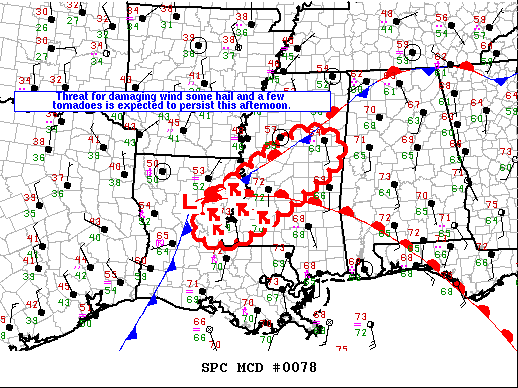
THE NATIONAL WEATHER SERVICE HAS ISSUED TORNADO WATCH 22 IN EFFECT UNTIL 6 PM CST THIS EVENING FOR THE FOLLOWING AREAS
IN LOUISIANA THIS WATCH INCLUDES 3 PARISHES
IN SOUTHEAST LOUISIANA
EAST FELICIANA POINTE COUPEE WEST FELICIANA
IN MISSISSIPPI THIS WATCH INCLUDES 2 COUNTIES
IN SOUTHERN MISSISSIPPI
AMITE WILKINSON
THIS INCLUDES THE CITIES OF CENTREVILLE, CLINTON, DOLOROSA, FELPS, FORT ADAMS, GILLSBERG, GLOSTER, JACKSON, LETTSWORTH, LIBERTY, LIVONIA, NEW ROADS, SMITHDALE, SPILLMAN, ST. FRANCISVILLE, WAKEFIELD, AND WOODVILLE.
Buying or Selling Real Estate?--->scottguidry.com United Real Estate Partners - New Orleans / North Shore Scott Guidry, Realtor, ABR, AHWD, AWREP, C2EX Click HERE To Download My FREE MLS Touch App! NWS COOP ID: 16-7425-08 CoCoRaHs ID: LA-TG-23
SKYSUMMIT
Administrator President | Director of Operations
Severe Thunderstorm Warning National Weather Service New Orleans LA 227 PM CST Wed Feb 5 2020
The National Weather Service in New Orleans has issued a
* Severe Thunderstorm Warning for... Southeastern West Baton Rouge Parish in southeastern Louisiana... Northwestern Livingston Parish in southeastern Louisiana... Central Iberville Parish in southeastern Louisiana... East Baton Rouge Parish in southeastern Louisiana...
* Until 300 PM CST.
* At 227 PM CST, a severe thunderstorm was located near Addis, or near Plaquemine, moving northeast at 55 mph.
HAZARD...60 mph wind gusts and quarter size hail.
SOURCE...Radar indicated.
IMPACT...Hail damage to vehicles is expected. Expect wind damage to roofs, siding, and trees.
* Locations impacted include... Baton Rouge, Zachary, Baker, Denham Springs, Plaquemine, Port Allen, Oak Hills Place, Addis, Brusly, Westminster, Merrydale, Inniswold, Watson, Pride, Gardere, Brownfields, Greenwell Spring and Baton Rouge Airport.
PRECAUTIONARY/PREPAREDNESS ACTIONS...
A Tornado Watch remains in effect until 600 PM CST for southeastern Louisiana.
Prepare immediately for large hail and damaging winds. People outside should move immediately to shelter inside a strong building. Stay away from windows.
To report severe weather, contact your nearest law enforcement agency. They will send your report to the National Weather Service office in New Orleans.
&&
Buying or Selling Real Estate?--->scottguidry.com United Real Estate Partners - New Orleans / North Shore Scott Guidry, Realtor, ABR, AHWD, AWREP, C2EX Click HERE To Download My FREE MLS Touch App! NWS COOP ID: 16-7425-08 CoCoRaHs ID: LA-TG-23
SKYSUMMIT
Administrator President | Director of Operations
6 NE Chalmette [Orleans Co, LA] MESONET reports TSTM WND GST of M56 MPH at 1:40 PM CST -- WEATHERFLOW STATION REPORTS 56 MPH WIND GUST.
Buying or Selling Real Estate?--->scottguidry.com United Real Estate Partners - New Orleans / North Shore Scott Guidry, Realtor, ABR, AHWD, AWREP, C2EX Click HERE To Download My FREE MLS Touch App! NWS COOP ID: 16-7425-08 CoCoRaHs ID: LA-TG-23
SKYSUMMIT
Administrator President | Director of Operations
Zachary [East Baton Rouge Co, LA] BROADCAST MEDIA reports HAIL of mothball size (E0.50 INCH) at 3:00 PM CST -- MEDIA REPORTS DIME-SIZED HAIL NORTHEAST OF ZACHARY IN EAST BATON ROUGE PARISH.
Buying or Selling Real Estate?--->scottguidry.com United Real Estate Partners - New Orleans / North Shore Scott Guidry, Realtor, ABR, AHWD, AWREP, C2EX Click HERE To Download My FREE MLS Touch App! NWS COOP ID: 16-7425-08 CoCoRaHs ID: LA-TG-23
SKYSUMMIT
Administrator President | Director of Operations
4 ENE Martinville [Simpson Co, MS] STORM CHASER reports TORNADO at 3:03 PM CST -- TREES AND POWER LINES DOWN ALONG HWY 540, STORM CHASER ALSO HAD VISUAL CONFIRMATION OF TORNADO.
Last Edit: Feb 5, 2020 15:18:12 GMT -6 by SKYSUMMIT
Buying or Selling Real Estate?--->scottguidry.com United Real Estate Partners - New Orleans / North Shore Scott Guidry, Realtor, ABR, AHWD, AWREP, C2EX Click HERE To Download My FREE MLS Touch App! NWS COOP ID: 16-7425-08 CoCoRaHs ID: LA-TG-23
northshoreelise: not on the 12z...
Oct 10, 2024 12:15:21 GMT -6
lencast: Really would appreciate it. Thank you, Lena
Sept 27, 2024 5:20:46 GMT -6
lencast: I am in Jacksonville, and trying to drive back to New Orleans. Does anyone here know if the I-10 is passable in Lake City and Tallahassee.
Sept 27, 2024 5:19:03 GMT -6
tcane: This sure looks like it dies quickly. maybe falling apart before metro New Orleans? Just looking at the lat dozen posts and images here.
Sept 10, 2024 11:26:27 GMT -6
rebekahb-Metairie: Looks like it but I wait for the better trained eyes on the forum to respond.
Sept 9, 2024 18:52:32 GMT -6
SKYSUMMIT: Oh sorry guys! I didn't eve see these new messages down here lol
Jul 26, 2024 13:14:47 GMT -6
jenniqtip: Just as soon as* sry fat finger
Jul 7, 2024 12:53:35 GMT -6
jenniqtip: I donate every year. 😀ju sry as soon as the first area of interest pops up!! I rarely post though so the tag isn’t necessary. Just know I appreciate everything you do!!
Jul 7, 2024 12:53:12 GMT -6
larcat: SKYSUMMIT You can slap one on me
Jul 7, 2024 12:12:03 GMT -6
SKYSUMMIT: Thanks laismyhome ! Also, if there is anyone who has donated that has not been given the Supporter tag, please let us know.
Jul 7, 2024 4:00:50 GMT -6
laismyhome: Here's a friendly reminder to go make a donation to support this forum that is so full of valuable reliable info. Link to donate is on homepage
Jul 2, 2024 9:55:24 GMT -6
Deleted: Ernesto gonna mog hard. I'm voting Alberto, Ernesto, Rafael and Deshawn
Apr 1, 2024 19:15:21 GMT -6
SKYSUMMIT: ShanaBanana Yes...just click the link and then send a PM to either TIgergirl or myself. I can then shoot her a text letting her know and I'll add your supporter tag. THANK YOU!!!!
Sept 23, 2023 16:08:37 GMT -6
ShanaBanana: At the risk of this being a dumb question. In order to donate, do I follow the instructions when I click “donate”, and then message tigergirl? I see people comment here that they donated, so I wasn’t sure if that had changed.
Sept 20, 2023 10:54:40 GMT -6
SKYSUMMIT: Great to have you back!
Sept 11, 2023 12:20:30 GMT -6
virginialee: Hi Skysummit: I was part of this back at the beginning. So happy to be back.
Sept 8, 2023 5:08:12 GMT -6
SKYSUMMIT: Thanks to everyone who has recently donated! If I missed anyone and you still need a Supporter Tag, let me know.
Sept 7, 2023 13:20:10 GMT -6
akeller11: Just donated
Sept 6, 2023 11:11:36 GMT -6
SKYSUMMIT: Thanks guys and gals! You're very much appreciated!
Aug 30, 2023 11:48:38 GMT -6