Post by SKYSUMMIT on Oct 27, 2021 6:13:49 GMT -6

...THERE IS AN ENHANCED RISK OF SEVERE THUNDERSTORMS ACROSS SOUTHERN
LA...
...SUMMARY...
Isolated to scattered severe thunderstorms capable of producing
damaging winds and a few tornadoes should occur Wednesday into
Wednesday night across parts of east/southeast Texas across
Louisiana to the central Gulf Coast.
...Synopsis...
Shortwave trough currently moving into the southern Plains will
continues east-southeastward throughout the day while deepening and
maturing. Surface low associated with this shortwave is currently
over northwest OK. The expectation is for this low to move eastward
just ahead of the upper trough through the day, before beginning to
occlude later this evening. A secondary surface low will likely
develop farther south and east (over southeast TX) during the
afternoon, progressing eastward across southern LA throughout the
late afternoon/evening.
...East TX through Lower MS Valley into the Central Gulf Coast...
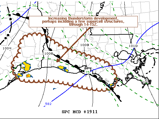
The line of storms currently extending from central OK southwestward
into southwest TX is forecast to continue eastward across southeast
OK/east TX this morning and through the lower MS Valley during the
afternoon and evening. A very moist airmass will be in place across
the Lower MS Valley ahead of this line of storms, with dewpoints
likely in the low 70s across much of LA. Despite these moist
low-level conditions, warm mid-level temperatures will keep buoyancy
modest. In contrast to the modest thermodynamics, low-level
kinematic profiles will be quite strong. Consensus among the
guidance forecasts around 200 m2/s2 of 0-1 km storm-relative
helicity throughout the warm sector preceding the convective line.
These conditions will support the persistence of the convective
line, which an attendant threat for damaging wind gusts and
brief/embedded QLCS tornadoes. Additionally, these conditions
support supercells with any discrete warm sector development.
Confidence in discrete warm sector storms has increased enough to
merit the delineation of a small 10% tornado probability across
southern LA. The potential for embedded/QLCS tornadoes also appears
to be maximized in this region.
This tornado and damaging wind threat will shift eastward into
southern MS/AL Wednesday evening and the FL Panhandle Wednesday
night/early Thursday morning. Sufficient boundary layer-instability
to support surface-based storms becomes more uncertain with eastward
extent across these areas, and the line should eventually weaken
late Wednesday night.
...Southwest/South-Central AR...Northwest LA...
A low-topped convective line may develop Wednesday afternoon across
parts of eastern OK/TX into western/southern AR along or just ahead
of the cold front. Even though low-level moisture will be more
limited across this area, cold mid-level temperatures associated
with the upper trough may still support weak destabilization. Strong
low/deep-layer shear suggest some threat for isolated damaging winds
and perhaps even a brief tornado if the line develops. This threat
will lessen Wednesday evening across AR owing to waning instability
with the loss of daytime heating.
..Mosier/Squitieri.. 10/27/2021