Post by futuremet on Jul 25, 2008 0:08:13 GMT -6
Forecast Verification- Originally Issued July 20th around 10pm
I was going to post this in the Dolly thread but it was locked so I'm just making another thread.
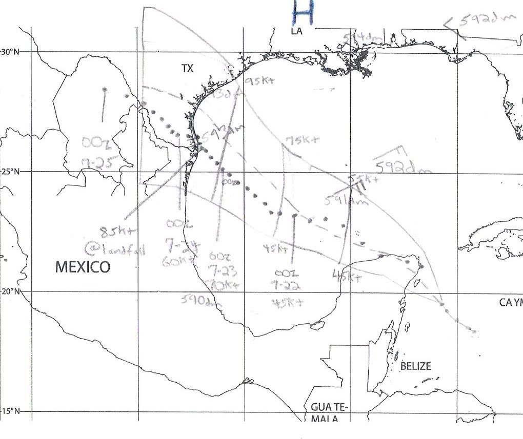
Timing- This was the biggest weakness in the forecast. Initially it appeared as if the Upper level low to the west of Dolly combined with the ridge to the north would create enhanced Easterlies for the next 24 hours or so. This was in fact the case however speed was grossly underestimated. Speed in the initial 24 hours was forecast to be 11-13 knots. Dolly instead travelled at 15-17 knots. Hours 24-48 of Dolly since the forecast was issued: She moved about the speed that was forecast, however, large forecast timing error in the first 24 hours caused this one to be far behind as well. She slowed down a little more than anticipated near the coast, causing the 72 hour actual point to be the closest to a forecast point.
Track- This part of the forecast was much closer to verification. In the first 24 hours, Dolly deviated an average of less than 20nm from center forecast line. In hours 24-48 the forecast error grew as expected. The average error was appx. 50-55nm. This was resultant of her faster westward movement, slightly stronger ridge/slower breaking down than anticipated, and somewhat lingering ULL to her south. In hours 48-72 average forecast error increased once again as expected to appx. 70nm. Landfall was forecasted appx. 75nm north of actual landfall.
Intensity- Initially Dolly strengthened slower then forecasted likely caused by effects of the lingering upper level low and interaction with the Yucatan. Also, the anticyclone forecasted to be over top Dolly was slightly to the east through the first 48 hours. Beyond this point, conditions became very favorable for development. Dolly maxed out at 85 knots compared to my forecast of 95 knots.
The NHC verified quite well on this storm. They initially had the forecast intensity too low but quickly revised the forecast. They actually had > or = errors in some of the 12-24 hour forecasts then they did in the 48-72+ hour forecasts. They initially also had the storm travelling to slow and making landfall late wednesday/early thursday. Overall, though, they did a great job succesfully forecasting this storm.
Models-I won't get into much detail with this right now. I'll go back and look more closely when I have more time. Off the top of my head the GFS did well picking up on the increased speed early on followed by the slow down later on. The EURO did decent, though was too far south into Mexico for several of its runs. The NAM and HWRF continuosly showed a slowing at the coast followed by a more northerly component, which did occur; however not to the extent they showed. Overall models did fairly well with Dolly once she developed.
I was going to post this in the Dolly thread but it was locked so I'm just making another thread.
Timing- This was the biggest weakness in the forecast. Initially it appeared as if the Upper level low to the west of Dolly combined with the ridge to the north would create enhanced Easterlies for the next 24 hours or so. This was in fact the case however speed was grossly underestimated. Speed in the initial 24 hours was forecast to be 11-13 knots. Dolly instead travelled at 15-17 knots. Hours 24-48 of Dolly since the forecast was issued: She moved about the speed that was forecast, however, large forecast timing error in the first 24 hours caused this one to be far behind as well. She slowed down a little more than anticipated near the coast, causing the 72 hour actual point to be the closest to a forecast point.
Track- This part of the forecast was much closer to verification. In the first 24 hours, Dolly deviated an average of less than 20nm from center forecast line. In hours 24-48 the forecast error grew as expected. The average error was appx. 50-55nm. This was resultant of her faster westward movement, slightly stronger ridge/slower breaking down than anticipated, and somewhat lingering ULL to her south. In hours 48-72 average forecast error increased once again as expected to appx. 70nm. Landfall was forecasted appx. 75nm north of actual landfall.
Intensity- Initially Dolly strengthened slower then forecasted likely caused by effects of the lingering upper level low and interaction with the Yucatan. Also, the anticyclone forecasted to be over top Dolly was slightly to the east through the first 48 hours. Beyond this point, conditions became very favorable for development. Dolly maxed out at 85 knots compared to my forecast of 95 knots.

The NHC verified quite well on this storm. They initially had the forecast intensity too low but quickly revised the forecast. They actually had > or = errors in some of the 12-24 hour forecasts then they did in the 48-72+ hour forecasts. They initially also had the storm travelling to slow and making landfall late wednesday/early thursday. Overall, though, they did a great job succesfully forecasting this storm.
Models-I won't get into much detail with this right now. I'll go back and look more closely when I have more time. Off the top of my head the GFS did well picking up on the increased speed early on followed by the slow down later on. The EURO did decent, though was too far south into Mexico for several of its runs. The NAM and HWRF continuosly showed a slowing at the coast followed by a more northerly component, which did occur; however not to the extent they showed. Overall models did fairly well with Dolly once she developed.


