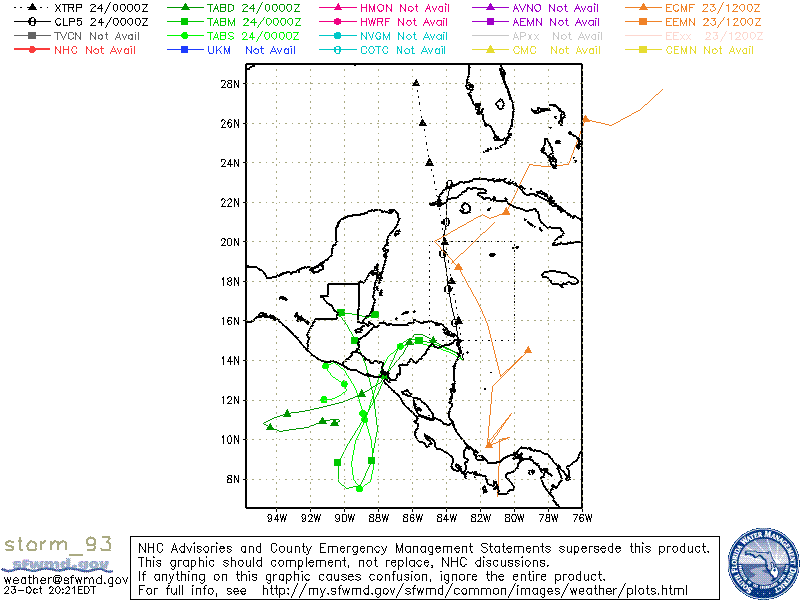
Post by Briella - Houma on Oct 23, 2017 5:17:13 GMT -6
ORANGE
Tropical Weather Outlook NWS National Hurricane Center Miami FL 200 AM EDT Mon Oct 23 2017
For the North Atlantic...Caribbean Sea and the Gulf of Mexico:
1. A broad area of low pressure is expected to form over the southwestern Caribbean Sea during the next few days. Slow development of this system is possible thereafter while it moves northwestward to northward. * Formation chance through 48 hours...low...near 0 percent. * Formation chance through 5 days...medium...40 percent.
Last Edit: Oct 28, 2017 20:30:38 GMT -6 by SKYSUMMIT
Buying or Selling Real Estate?--->scottguidry.com United Real Estate Partners - New Orleans / North Shore Scott Guidry, Realtor, ABR, AHWD, AWREP, C2EX Click HERE To Download My FREE MLS Touch App! NWS COOP ID: 16-7425-08 CoCoRaHs ID: LA-TG-23
Post by Briella - Houma on Oct 26, 2017 15:14:12 GMT -6
Tropical Weather Outlook NWS National Hurricane Center Miami FL 200 PM EDT Thu Oct 26 2017
For the North Atlantic...Caribbean Sea and the Gulf of Mexico:
1. Disorganized cloudiness and thunderstorms over the western Caribbean Sea are associated with a trough of low pressure. Environmental conditions are expected to be conducive for some development on Friday and Saturday as the system moves slowly northward over the northwestern Caribbean Sea. Strong upper-level winds associated with an approaching cold front will make conditions less favorable by Sunday. Regardless of development, this system is expected to produce locally heavy rainfall over the Cayman Islands, Jamaica, and portions of Cuba during the next day or two. These rains are forecast to spread northward across portions of South Florida and the Keys on Saturday, and over the northwestern Bahamas Saturday night and Sunday. * Formation chance through 48 hours...low...30 percent. * Formation chance through 5 days...medium...40 percent.
Tropical Weather Outlook NWS National Hurricane Center Miami FL 800 AM EDT Fri Oct 27 2017
For the North Atlantic...Caribbean Sea and the Gulf of Mexico:
Shower and thunderstorm activity has increased and become more concentrated in association with a trough of low pressure over the northwestern Caribbean Sea. Environmental conditions are expected to be conducive for development today and Saturday, and a tropical depression could form as the system moves northward over the northwestern Caribbean Sea. Increasing upper-level winds will make conditions less favorable when the system moves north of Cuba and merges with a cold front on Sunday. Interests in the Cayman Islands and central and western Cuba should monitor the progress of this system. Regardless of development, this disturbance is expected to produce locally heavy rainfall over the Cayman Islands, Jamaica, and portions of Cuba during the next day or two. These rains are forecast to spread northward across portions of South Florida and the Keys on Saturday, and over the northwestern Bahamas Saturday night and Sunday. An Air Force Reserve reconnaissance aircraft is scheduled to investigate this system this afternoon, if necessary. * Formation chance through 48 hours...medium...60 percent. * Formation chance through 5 days...medium...60 percent.
Post by hurricaner on Oct 27, 2017 11:47:17 GMT -6
Now at 80% and the recon plane is heading out to the system.
Tropical Weather Outlook NWS National Hurricane Center Miami FL 200 PM EDT Fri Oct 27 2017
For the North Atlantic...Caribbean Sea and the Gulf of Mexico:
Showers and thunderstorms associated with a broad area of low pressure located over the northwestern Caribbean Sea are beginning to show signs of organization. Environmental conditions are expected to be conducive for additional development, and a tropical depression or tropical storm is likely to form later today or Saturday as the system moves northward over the northwestern Caribbean Sea before turning northeastward by late Saturday. Tropical storm watches and warnings may be needed for the Cayman Islands, central and western Cuba, and the central and northwestern Bahamas later today or tonight. Interests in the Florida Keys and South Florida should also monitor the progress of this disturbance. An Air Force Reserve reconnaissance aircraft is en route to investigate this system.
Regardless of development, this disturbance is expected to produce locally heavy rainfall over the Cayman Islands, Jamaica, and portions of Cuba during the next day or two. Rainfall is also forecast to spread northward across portions of South Florida and the Keys on Saturday, and over the northwestern and central Bahamas Saturday night and Sunday. * Formation chance through 48 hours...high...80 percent. * Formation chance through 5 days...high...80 percent.
Future Philipe is looking better this morning with a better circulation developing to the south of the Isle of Pines, heading towards Cuba, FL Straights and northern Bahamas.
Tropical Storm Philippe Intermediate Advisory Number 5A NWS National Hurricane Center Miami FL AL182017 800 PM EDT Sat Oct 28 2017
...PHILIPPE MOVING OVER THE STRAITS OF FLORIDA... ...HEAVY RAINS OCCURRING OVER CENTRAL CUBA AND SPREADING NORTHWARD ACROSS THE FLORIDA KEYS AND SOUTH FLORIDA...
SUMMARY OF 800 PM EDT...0000 UTC...INFORMATION ---------------------------------------------- LOCATION...23.7N 82.5W ABOUT 50 MI...80 KM N OF HAVANA CUBA ABOUT 75 MI...120 KM SW OF KEY WEST FLORIDA MAXIMUM SUSTAINED WINDS...40 MPH...65 KM/H PRESENT MOVEMENT...N OR 5 DEGREES AT 28 MPH...45 KM/H MINIMUM CENTRAL PRESSURE...1002 MB...29.59 INCHES
Buying or Selling Real Estate?--->scottguidry.com United Real Estate Partners - New Orleans / North Shore Scott Guidry, Realtor, ABR, AHWD, AWREP, C2EX Click HERE To Download My FREE MLS Touch App! NWS COOP ID: 16-7425-08 CoCoRaHs ID: LA-TG-23
SKYSUMMIT
Administrator President | Director of Operations
Tropical Storm Philippe Advisory Number 6 NWS National Hurricane Center Miami FL AL182017 1100 PM EDT Sat Oct 28 2017
...CENTER OF POORLY ORGANIZED PHILIPPE APPROACHING THE FLORIDA KEYS... ...HEAVY RAINS OCCURRING OVER FROM CENTRAL CUBA ACROSS SOUTHERN FLORIDA TO THE NORTHWESTERN BAHAMAS...
SUMMARY OF 1100 PM EDT...0300 UTC...INFORMATION ----------------------------------------------- LOCATION...24.8N 82.1W ABOUT 25 MI...40 KM NW OF KEY WEST FLORIDA MAXIMUM SUSTAINED WINDS...40 MPH...65 KM/H PRESENT MOVEMENT...NNE OR 15 DEGREES AT 24 MPH...39 KM/H MINIMUM CENTRAL PRESSURE...1003 MB...29.62 INCHES
Buying or Selling Real Estate?--->scottguidry.com United Real Estate Partners - New Orleans / North Shore Scott Guidry, Realtor, ABR, AHWD, AWREP, C2EX Click HERE To Download My FREE MLS Touch App! NWS COOP ID: 16-7425-08 CoCoRaHs ID: LA-TG-23
Shoutbox
northshoreelise: not on the 12z...
Oct 10, 2024 12:15:21 GMT -6
lencast: Really would appreciate it. Thank you, Lena
Sept 27, 2024 5:20:46 GMT -6
lencast: I am in Jacksonville, and trying to drive back to New Orleans. Does anyone here know if the I-10 is passable in Lake City and Tallahassee.
Sept 27, 2024 5:19:03 GMT -6
tcane: This sure looks like it dies quickly. maybe falling apart before metro New Orleans? Just looking at the lat dozen posts and images here.
Sept 10, 2024 11:26:27 GMT -6
rebekahb-Metairie: Looks like it but I wait for the better trained eyes on the forum to respond.
Sept 9, 2024 18:52:32 GMT -6
SKYSUMMIT: Oh sorry guys! I didn't eve see these new messages down here lol
Jul 26, 2024 13:14:47 GMT -6
jenniqtip: Just as soon as* sry fat finger
Jul 7, 2024 12:53:35 GMT -6
jenniqtip: I donate every year. 😀ju sry as soon as the first area of interest pops up!! I rarely post though so the tag isn’t necessary. Just know I appreciate everything you do!!
Jul 7, 2024 12:53:12 GMT -6
larcat: SKYSUMMIT You can slap one on me
Jul 7, 2024 12:12:03 GMT -6
SKYSUMMIT: Thanks laismyhome ! Also, if there is anyone who has donated that has not been given the Supporter tag, please let us know.
Jul 7, 2024 4:00:50 GMT -6
laismyhome: Here's a friendly reminder to go make a donation to support this forum that is so full of valuable reliable info. Link to donate is on homepage
Jul 2, 2024 9:55:24 GMT -6
Deleted: Ernesto gonna mog hard. I'm voting Alberto, Ernesto, Rafael and Deshawn
Apr 1, 2024 19:15:21 GMT -6
SKYSUMMIT: ShanaBanana Yes...just click the link and then send a PM to either TIgergirl or myself. I can then shoot her a text letting her know and I'll add your supporter tag. THANK YOU!!!!
Sept 23, 2023 16:08:37 GMT -6
ShanaBanana: At the risk of this being a dumb question. In order to donate, do I follow the instructions when I click “donate”, and then message tigergirl? I see people comment here that they donated, so I wasn’t sure if that had changed.
Sept 20, 2023 10:54:40 GMT -6
SKYSUMMIT: Great to have you back!
Sept 11, 2023 12:20:30 GMT -6
virginialee: Hi Skysummit: I was part of this back at the beginning. So happy to be back.
Sept 8, 2023 5:08:12 GMT -6
SKYSUMMIT: Thanks to everyone who has recently donated! If I missed anyone and you still need a Supporter Tag, let me know.
Sept 7, 2023 13:20:10 GMT -6
akeller11: Just donated
Sept 6, 2023 11:11:36 GMT -6
SKYSUMMIT: Thanks guys and gals! You're very much appreciated!
Aug 30, 2023 11:48:38 GMT -6