Yes...EXTREMELY dangerous situation out there today
Buying or Selling Real Estate?--->scottguidry.com United Real Estate Partners - New Orleans / North Shore Scott Guidry, Realtor, ABR, AHWD, AWREP, C2EX Click HERE To Download My FREE MLS Touch App! NWS COOP ID: 16-7425-08 CoCoRaHs ID: LA-TG-23
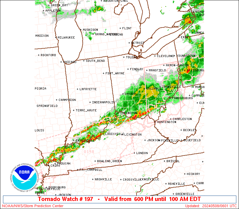
Tornado Watch Number 197 NWS Storm Prediction Center Norman OK 1235 PM CDT Mon May 20 2019
The NWS Storm Prediction Center has issued a
* Tornado Watch for portions of West Texas including much of the Panhandle
* Effective this Monday afternoon and evening from 1235 PM until 800 PM CDT.
...THIS IS A PARTICULARLY DANGEROUS SITUATION...
* Primary threats include... Numerous tornadoes expected with a few intense tornadoes likely Widespread large hail and scattered very large hail events to 4 inches in diameter expected Widespread damaging wind gusts to 70 mph likely
SUMMARY...Intense tornadic supercell thunderstorms are expected to develop across west Texas as the eastern half of the Texas Panhandle. In addition to the risk of strong tornadoes, very large hail and damaging winds are likely in the strongest cells.
The tornado watch area is approximately along and 55 statute miles east and west of a line from 50 miles east northeast of Amarillo TX to 35 miles east of Big Spring TX. For a complete depiction of the watch see the associated watch outline update (WOUS64 KWNS WOU7).
PRECAUTIONARY/PREPAREDNESS ACTIONS...
REMEMBER...A Tornado Watch means conditions are favorable for tornadoes and severe thunderstorms in and close to the watch area. Persons in these areas should be on the lookout for threatening weather conditions and listen for later statements and possible warnings.
&&
Buying or Selling Real Estate?--->scottguidry.com United Real Estate Partners - New Orleans / North Shore Scott Guidry, Realtor, ABR, AHWD, AWREP, C2EX Click HERE To Download My FREE MLS Touch App! NWS COOP ID: 16-7425-08 CoCoRaHs ID: LA-TG-23
SKYSUMMIT
Administrator President | Director of Operations
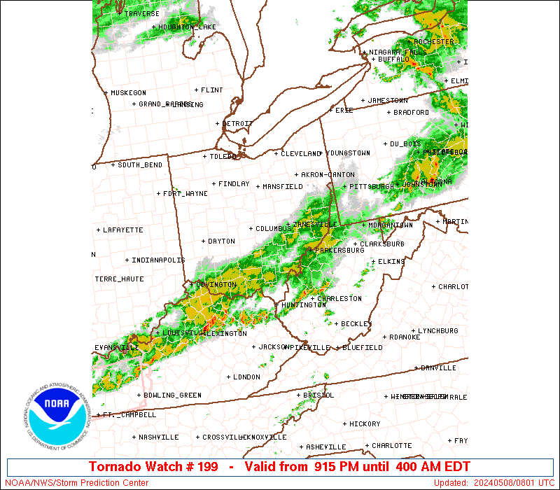
Tornado Watch Number 199 NWS Storm Prediction Center Norman OK 135 PM CDT Mon May 20 2019
The NWS Storm Prediction Center has issued a
* Tornado Watch for portions of Central and Western Oklahoma Northwest Texas
* Effective this Monday afternoon and evening from 135 PM until 1000 PM CDT.
...THIS IS A PARTICULARLY DANGEROUS SITUATION...
* Primary threats include... Numerous tornadoes and several intense tornadoes expected Widespread damaging winds and scattered significant gusts to 80 mph expected Widespread large hail and scattered very large hail events to 4 inches in diameter expected
SUMMARY...An outbreak of tornadoes, including the risk of intense and long-track tornadoes, is expected to develop this afternoon across the watch area. Very large hail and damaging wind gusts are expected with the numerous supercell storms.
The tornado watch area is approximately along and 95 statute miles north and south of a line from 40 miles west of Altus OK to 50 miles east southeast of Chandler OK. For a complete depiction of the watch see the associated watch outline update (WOUS64 KWNS WOU9).
PRECAUTIONARY/PREPAREDNESS ACTIONS...
REMEMBER...A Tornado Watch means conditions are favorable for tornadoes and severe thunderstorms in and close to the watch area. Persons in these areas should be on the lookout for threatening weather conditions and listen for later statements and possible warnings.
&&
Buying or Selling Real Estate?--->scottguidry.com United Real Estate Partners - New Orleans / North Shore Scott Guidry, Realtor, ABR, AHWD, AWREP, C2EX Click HERE To Download My FREE MLS Touch App! NWS COOP ID: 16-7425-08 CoCoRaHs ID: LA-TG-23
northshoreelise: not on the 12z...
Oct 10, 2024 12:15:21 GMT -6
lencast: Really would appreciate it. Thank you, Lena
Sept 27, 2024 5:20:46 GMT -6
lencast: I am in Jacksonville, and trying to drive back to New Orleans. Does anyone here know if the I-10 is passable in Lake City and Tallahassee.
Sept 27, 2024 5:19:03 GMT -6
tcane: This sure looks like it dies quickly. maybe falling apart before metro New Orleans? Just looking at the lat dozen posts and images here.
Sept 10, 2024 11:26:27 GMT -6
rebekahb-Metairie: Looks like it but I wait for the better trained eyes on the forum to respond.
Sept 9, 2024 18:52:32 GMT -6
SKYSUMMIT: Oh sorry guys! I didn't eve see these new messages down here lol
Jul 26, 2024 13:14:47 GMT -6
jenniqtip: Just as soon as* sry fat finger
Jul 7, 2024 12:53:35 GMT -6
jenniqtip: I donate every year. 😀ju sry as soon as the first area of interest pops up!! I rarely post though so the tag isn’t necessary. Just know I appreciate everything you do!!
Jul 7, 2024 12:53:12 GMT -6
larcat: SKYSUMMIT You can slap one on me
Jul 7, 2024 12:12:03 GMT -6
SKYSUMMIT: Thanks laismyhome ! Also, if there is anyone who has donated that has not been given the Supporter tag, please let us know.
Jul 7, 2024 4:00:50 GMT -6
laismyhome: Here's a friendly reminder to go make a donation to support this forum that is so full of valuable reliable info. Link to donate is on homepage
Jul 2, 2024 9:55:24 GMT -6
Deleted: Ernesto gonna mog hard. I'm voting Alberto, Ernesto, Rafael and Deshawn
Apr 1, 2024 19:15:21 GMT -6
SKYSUMMIT: ShanaBanana Yes...just click the link and then send a PM to either TIgergirl or myself. I can then shoot her a text letting her know and I'll add your supporter tag. THANK YOU!!!!
Sept 23, 2023 16:08:37 GMT -6
ShanaBanana: At the risk of this being a dumb question. In order to donate, do I follow the instructions when I click “donate”, and then message tigergirl? I see people comment here that they donated, so I wasn’t sure if that had changed.
Sept 20, 2023 10:54:40 GMT -6
SKYSUMMIT: Great to have you back!
Sept 11, 2023 12:20:30 GMT -6
virginialee: Hi Skysummit: I was part of this back at the beginning. So happy to be back.
Sept 8, 2023 5:08:12 GMT -6
SKYSUMMIT: Thanks to everyone who has recently donated! If I missed anyone and you still need a Supporter Tag, let me know.
Sept 7, 2023 13:20:10 GMT -6
akeller11: Just donated
Sept 6, 2023 11:11:36 GMT -6
SKYSUMMIT: Thanks guys and gals! You're very much appreciated!
Aug 30, 2023 11:48:38 GMT -6