Tornado Warning National Weather Service New Orleans LA 450 PM CST Fri Nov 27 2020
The National Weather Service in New Orleans has issued a
* Tornado Warning for... Northern Hancock County in southern Mississippi... South central Pearl River County in southern Mississippi...
* Until 515 PM CST.
* At 450 PM CST, a severe thunderstorm capable of producing a tornado was located near Picayune, moving east at 15 mph.
HAZARD...Tornado.
SOURCE...Radar indicated rotation.
IMPACT...Flying debris will be dangerous to those caught without shelter. Mobile homes will be damaged or destroyed. Damage to roofs, windows, and vehicles will occur. Tree damage is likely.
* This tornadic thunderstorm will remain over mainly rural areas of northern Hancock and south central Pearl River Counties.
PRECAUTIONARY/PREPAREDNESS ACTIONS...
TAKE COVER NOW! Move to an interior room on the lowest floor of a sturdy building. Avoid windows. If you are outdoors, in a mobile home, or in a vehicle, move to the closest substantial shelter and protect yourself from flying debris.
To report severe weather contact your nearest law enforcement agency. They will send your report to the National Weather Service office in New Orleans.
Severe Thunderstorm Warning National Weather Service New Orleans LA 458 PM CST Fri Nov 27 2020
The National Weather Service in New Orleans has issued a
* Severe Thunderstorm Warning for... Southwestern Ascension Parish in southeastern Louisiana... West central St. James Parish in southeastern Louisiana... Southeastern Iberville Parish in southeastern Louisiana... North central Assumption Parish in southeastern Louisiana...
* Until 545 PM CST.
* At 457 PM CST, a severe thunderstorm was located over Bayou Sorrel, or 9 miles southwest of Plaquemine, moving east at 20 mph.
HAZARD...60 mph wind gusts and penny size hail.
SOURCE...Radar indicated.
IMPACT...Expect damage to roofs, siding, and trees.
* Locations impacted include... Gonzales, Donaldsonville, St. Gabriel, White Castle, Geismar, Bayou Sorrel, Carville and Belle Rose.
PRECAUTIONARY/PREPAREDNESS ACTIONS...
For your protection move to an interior room on the lowest floor of a building.
To report severe weather, contact your nearest law enforcement agency. They will send your report to the National Weather Service office in New Orleans.
From yesterday's storms, an EF-1 tornado was confirmed south of McComb by the National Weather Service.
4 S Mccomb [Pike Co, MS] NWS STORM SURVEY reports TORNADO of EF1 at 27 Nov, 3:00 PM CST -- NWS STORM SURVEY CONFIRMS EF-1 TORNADO OCCURRED SOUTH OF MCCOMB, MS. PATH LENGTH WAS 1.5 MILES AND PATH WIDTH WAS 50 YARDS. WINDS WERE ESTIMATED TO BE 100 MPH. TREES, A MOBILE HOME, AIRPORT HANGARS, AND AIRCRAFT WERE DAMAGED ALONG THE PATH OF THE TORNADO.
Buying or Selling Real Estate?--->scottguidry.com Click HERE To Download My FREE MLS Touch App! NWS COOP ID: 16-7425-08 CoCoRaHs ID: LA-TG-23
SKYSUMMIT
Administrator President | Director of Operations
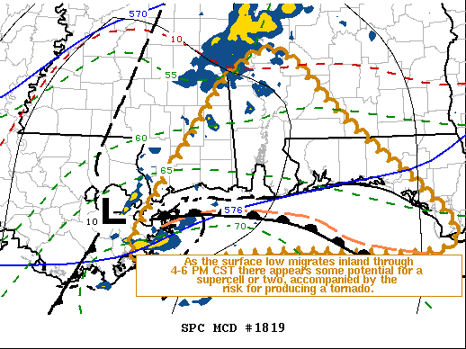
Mesoscale Discussion 1819 NWS Storm Prediction Center Norman OK 0240 PM CST Sun Nov 29 2020
Areas affected...Parts of southeastern Louisiana...southeastern Mississippi....southwestern Alabama and the western Florida Panhandle
Concerning...Severe potential...Watch unlikely
Valid 292040Z - 292315Z
Probability of Watch Issuance...20 percent
SUMMARY...Some potential exists for the development of a supercell or two, accompanied by the risk for producing a tornado, as a deepening surface low continues to migrate inland of the coast through 4-6 PM CST. It is not yet clear that a severe weather watch will be needed, but trends will continue to be monitored.
DISCUSSION...A surface frontal low continues to develop inland of north central Gulf coastal areas (near New Orleans, LA as of 20Z). The Rapid Refresh has been indicating further deepening is likely through the remainder of the afternoon, with a more rapid north-northeastward migration toward the Selma AL vicinity by 30/00Z, as a vigorous upstream short wave trough begins pivoting northeastward through the lower Mississippi Valley.
Strongest southerly 850 mb flow is now inland of the coast in a belt across southeastern Mississippi through much of southern Alabama and the western Florida Panhandle, where clockwise-curved low-level hodographs are largest and becoming most conducive to potential for storms capable of producing tornadoes. Deep-layer wind fields are expected to become more favorable, as west-southwesterly flow in the 700-500 mb layer strengthens across this region through early evening.
More problematic to severe weather potential, seasonably moist boundary-layer air remains largely confined to areas offshore of the Gulf coast, and forecast soundings are suggestive that a residual near surface stable layer may persist inland of coastal areas even as the surface low center migrates inland. However, trends in latest objective surface analysis hint that at least some modification may be underway.
Given the deepening nature of the surface low, it may not be out of the question that boundary-layer destabilization could become sufficient to support an intensifying warm sector storm or two late this afternoon. If this occurs, the wind profiles will be conducive to the evolution of supercells, with the potential to produce a tornado.
..Kerr/Hart.. 11/29/2020
Buying or Selling Real Estate?--->scottguidry.com Click HERE To Download My FREE MLS Touch App! NWS COOP ID: 16-7425-08 CoCoRaHs ID: LA-TG-23
SKYSUMMIT
Administrator President | Director of Operations
Tornado Warning National Weather Service Mobile AL 324 PM CST Sun Nov 29 2020
The National Weather Service in Mobile has issued a
* Tornado Warning for... Southeastern Baldwin County in southwestern Alabama...
* Until 400 PM CST.
* At 324 PM CST, a severe thunderstorm capable of producing a tornado was located 4 miles east of Bon Secour, or 4 miles northeast of Gulf Shores, moving northeast at 35 mph.
HAZARD...Tornado.
SOURCE...Radar indicated rotation.
IMPACT...Flying debris will be dangerous to those caught without shelter. Mobile homes will be damaged or destroyed. Damage to roofs, windows, and vehicles will occur. Tree damage is likely.
* This dangerous storm will be near... Elberta around 335 PM CST. Lillian around 350 PM CST.
PRECAUTIONARY/PREPAREDNESS ACTIONS...
TAKE COVER NOW! Move to a basement or an interior room on the lowest floor of a sturdy building. Avoid windows. If you are outdoors, in a mobile home, or in a vehicle, move to the closest substantial shelter and protect yourself from flying debris.
ozell: Ernesto gonna mog hard. I'm voting Alberto, Ernesto, Rafael and Deshawn
Apr 1, 2024 19:15:21 GMT -6
SKYSUMMIT: Farmasi gal (slprejean) Yes...just click the link and then send a PM to either TIgergirl or myself. I can then shoot her a text letting her know and I'll add your supporter tag. THANK YOU!!!!
Sept 23, 2023 16:08:37 GMT -6
Farmasi gal (slprejean): At the risk of this being a dumb question. In order to donate, do I follow the instructions when I click “donate”, and then message tigergirl? I see people comment here that they donated, so I wasn’t sure if that had changed.
Sept 20, 2023 10:54:40 GMT -6
SKYSUMMIT: Great to have you back!
Sept 11, 2023 12:20:30 GMT -6
virginialee: Hi Skysummit: I was part of this back at the beginning. So happy to be back.
Sept 8, 2023 5:08:12 GMT -6
SKYSUMMIT: Thanks to everyone who has recently donated! If I missed anyone and you still need a Supporter Tag, let me know.
Sept 7, 2023 13:20:10 GMT -6
akeller11: Just donated
Sept 6, 2023 11:11:36 GMT -6
SKYSUMMIT: Thanks guys and gals! You're very much appreciated!
Aug 30, 2023 11:48:38 GMT -6
nolachic: Well peeps, it's this time of year. Good to see everyone back. Hopefully, this season allows us to go way off topic and just shoot the shit instead of crapping our pants! Cheers to all! E
Aug 27, 2023 13:19:41 GMT -6
dwill31: Just donated $100 and the message to to Im you
Aug 25, 2023 16:58:49 GMT -6
grisairgasm: Hope u are doing well. Saw u at the clinic a few weeks back and wanted to say high but looked like u were with a patient. G
Aug 22, 2023 17:53:18 GMT -6
SKYSUMMIT: schexstorm I just replied to your post. I believe it's a glitch b/c you're not the first person I hear this from. You're not banned.
Jun 27, 2023 5:29:04 GMT -6
schexstorm: opened up the site on my phone this am and it said I was banned from the forum? I never posted or anything. Do you know what could be the problem? thanks
Jun 24, 2023 6:38:13 GMT -6
SKYSUMMIT: I keep forgetting we have a chat box down here lol
May 4, 2023 15:48:01 GMT -6
saintlybraves: where is this so called "low" supposed to develop? Any better indications with modeling today? We are going to Destin this week and of course I'd like for a more westerly setup.
Apr 10, 2023 16:04:49 GMT -6
mysterionz: hello I’m new here
Apr 3, 2023 15:56:46 GMT -6
frankp: Hey neighbor can u please send me the local Alabama weather forum that you follow, much appreciated… frank
Jan 21, 2023 13:57:45 GMT -6
frankp: Hey neighbor, can u send the the link of the Alabama weather forum you visit, much appreciated
Jan 21, 2023 13:55:49 GMT -6