Does anyone else feel that Channel 4 is starting to downplay the storm...well Eric anyway? I understand that they are trying to not cause panic but I find he's kind of like "whew" that was close when in all actuality it's not over! There's still time for intensification.
The problem with those newscasts is that New Orleans has not truly experienced sustained hurricane conditions since Betsy. Yes, Gustav had some nice gusts and Katrina had gusts in the 90's I believe....but gusts.
Lots of people will be surprised just how strong sustained winds in the 90's with gusts to 115mph are.
Thanks Sky...and after you posting about sustained 90mph winds I'm rethinking cancelling my reservations!! HAHA! My children will need a sedative to survive through that! My reservations are in Shreveport - don't know how good of a move that was but I got a room. I have until today at 4 to cancel. What are your thoughts?? Stay or go?? haha!
My daughter just called me and her work, Whitney bank is not closing at all. WTH is wrong with them? Having employees out in 90 plus winds. Ridiculous!
As of right now, my DH has to go from the River Parishes to downtown New Orleans for work tomorrow. He then has to drive his truck back to the River Parishes, run his route, get back downtown, and then drive back home. I am strongly hoping they will change their mind. Especially since that big delivery truck is tall and the wind will push it around.
. When the weather starts declining, maybe they will change their minds. People need to be with their families through this.
Proud Wife, Mommy of 3 & Gramma of 5.
mrjamie
GCWX Supporter Vice President | Chief Consultant
The cone represents the probable track of the center of a tropical cyclone, and is formed by enclosing the area swept out by a set of circles (not shown) along the forecast track (at 12, 24, 36 hours, etc). The size of each circle is set so that two-thirds of historical official forecast errors over a 5-year sample fall within the circle. The circle radii defining the cones in 2011 for the Atlantic and eastern North Pacific basins are given in the table below.
One can also examine historical tracks to determine how often the entire 5-day path of a cyclone remains completely within the area of the cone. This is a different perspective that ignores most timing errors. For example, a storm moving very slowly but in the expected direction would still be within the area of the cone, even though the track forecast error could be very large. Based on forecasts over the previous 5 years, the entire track of the tropical cyclone can be expected to remain within the cone roughly 60-70% of the time.
Radii of NHC forecast cone circles for 2011, based on error statistics from 2006-2010:
Post by Zack Fradella on Aug 27, 2012 11:20:08 GMT -6
You try to find a silver lining and there is. When the going starts to get tough tomorrow, the tune will change as we realize the punch this thing may have.
Also, when this does become a hurricane things will change.
Plenty of strong tropical force winds in the NW, far, far away for the LLC. The kind of winds Nola should be experiencing as early as tomorrow morning.
I just wanted to say thank you to everyone that has been posting throughout this event. I have been following this board for quite a few days. Reading these posts helps me to feel better informed about decisions we make regarding evacuation, etc. I know this is a little off topic, but I just wanted to share my gratitude. Thanks, and keep up the good work!
My daughter just called me and her work, Whitney bank is not closing at all. WTH is wrong with them? Having employees out in 90 plus winds. Ridiculous!
THAT IS RIDICOULOUS!!! I could not drive in that.. eeek
My wife works at a five & dime, ahem, dollar store and they said as long as there is no mandatory evacuation they are going to open. Well, good luck with that.
I really need HELP making a decision! I trust all of you! My husband thinks we should leave, I don't want to... We live in Belle Chasse .... How bad do you think this will get. I have little children
Post by Zack Fradella on Aug 27, 2012 11:26:33 GMT -6
Get ready, I am about to open a can of worms!!!
Comparison:
Hurricane Katrina
Isaac
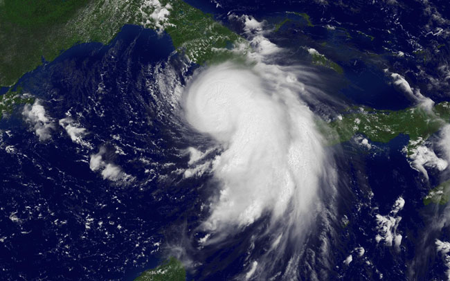
I am just showing the ironic nature that Isaac is a backwards Katrina when she was over the Keys. No, this is not about to explode but it does look to be strengthening if the storms can wrap around.
Hi I am not on the island i am in rigolets estates. Thanks for all the info we are leaving in a little while
That area fared a little better than on the island because the houses are alot newer and also most of them are much higher than those on that were on the island.
You know your house better than anyone, if you're closer to Hwy 90 and really high maybe you'll be OK, if you're closer to the Rigolets...........
Again, I don't think I'd ride it out over there. Too many things can happen. Someone's boat breaks loose and slams into your house and you're in big trouble. My FIL's house had a 40 ft shrimp boat jammed against the back of his house after Katrina. Luckily it didn't wipe it out, by being jammed where it was it actually helped protect it from everything else that was flying around.
Hi guys, what time will conditions start to deteriorate around New Orleans? Thanks for everything y'all do. This site keeps me sane during hurricane season!!!
Thanks so much. Yes we are 17 feet in the air but during Katrina a railroad container took out the second floor rear of my house. We are def leaving just trying to decide whether to go to my sons in Metairie or up to Memphis, Thanks for the thoughts and prayers
Shoutbox
northshoreelise: not on the 12z...
Oct 10, 2024 12:15:21 GMT -6
lencast: Really would appreciate it. Thank you, Lena
Sept 27, 2024 5:20:46 GMT -6
lencast: I am in Jacksonville, and trying to drive back to New Orleans. Does anyone here know if the I-10 is passable in Lake City and Tallahassee.
Sept 27, 2024 5:19:03 GMT -6
tcane: This sure looks like it dies quickly. maybe falling apart before metro New Orleans? Just looking at the lat dozen posts and images here.
Sept 10, 2024 11:26:27 GMT -6
rebekahb-Metairie: Looks like it but I wait for the better trained eyes on the forum to respond.
Sept 9, 2024 18:52:32 GMT -6
SKYSUMMIT: Oh sorry guys! I didn't eve see these new messages down here lol
Jul 26, 2024 13:14:47 GMT -6
jenniqtip: Just as soon as* sry fat finger
Jul 7, 2024 12:53:35 GMT -6
jenniqtip: I donate every year. 😀ju sry as soon as the first area of interest pops up!! I rarely post though so the tag isn’t necessary. Just know I appreciate everything you do!!
Jul 7, 2024 12:53:12 GMT -6
larcat: SKYSUMMIT You can slap one on me
Jul 7, 2024 12:12:03 GMT -6
SKYSUMMIT: Thanks laismyhome ! Also, if there is anyone who has donated that has not been given the Supporter tag, please let us know.
Jul 7, 2024 4:00:50 GMT -6
laismyhome: Here's a friendly reminder to go make a donation to support this forum that is so full of valuable reliable info. Link to donate is on homepage
Jul 2, 2024 9:55:24 GMT -6
Deleted: Ernesto gonna mog hard. I'm voting Alberto, Ernesto, Rafael and Deshawn
Apr 1, 2024 19:15:21 GMT -6
SKYSUMMIT: ShanaBanana Yes...just click the link and then send a PM to either TIgergirl or myself. I can then shoot her a text letting her know and I'll add your supporter tag. THANK YOU!!!!
Sept 23, 2023 16:08:37 GMT -6
ShanaBanana: At the risk of this being a dumb question. In order to donate, do I follow the instructions when I click “donate”, and then message tigergirl? I see people comment here that they donated, so I wasn’t sure if that had changed.
Sept 20, 2023 10:54:40 GMT -6
SKYSUMMIT: Great to have you back!
Sept 11, 2023 12:20:30 GMT -6
virginialee: Hi Skysummit: I was part of this back at the beginning. So happy to be back.
Sept 8, 2023 5:08:12 GMT -6
SKYSUMMIT: Thanks to everyone who has recently donated! If I missed anyone and you still need a Supporter Tag, let me know.
Sept 7, 2023 13:20:10 GMT -6
akeller11: Just donated
Sept 6, 2023 11:11:36 GMT -6
SKYSUMMIT: Thanks guys and gals! You're very much appreciated!
Aug 30, 2023 11:48:38 GMT -6