I can't stand watching these newscasts. For days we've been talking about the possibility of Isaac moving right to the coast and stalling while steering currents collapse. Bob is talking about this like it's something brand new.
Isaac will not do what the NHC forecast is calling for.
Hey, new here, but have been reading the forums for the last couple of days. Wanted to say thanks for all the information y'all have been giving.
Sky, I was watching Bob Breck and it sounds like he's saying Isaac may go south-ish? He also commented about Ponchatoula, which is where we are, and I was wondering, are we..basically, out of the woods here?
If it HAS stalled, with so much of the center still over water\wetlands, gonna continue to strengthen? Whats your thoughts?
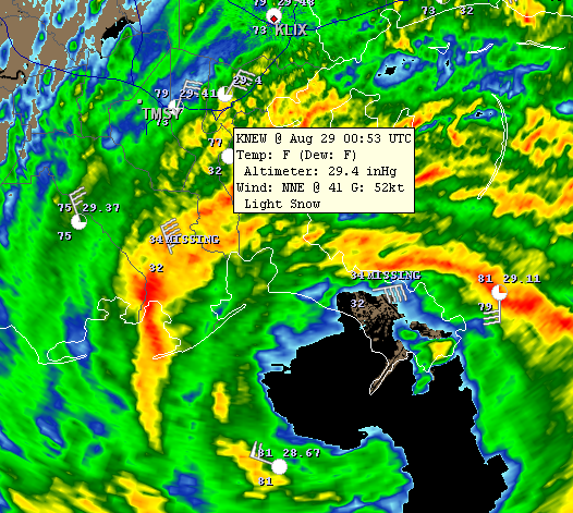
That is a real possibility I'm afraid to say. Current pressure is 968mb. We'll see if it drops any further.
Buying or Selling Real Estate?--->scottguidry.com United Real Estate Partners - New Orleans / North Shore Scott Guidry, Realtor, ABR, AHWD, AWREP, C2EX Click HERE To Download My FREE MLS Touch App! NWS COOP ID: 16-7425-08 CoCoRaHs ID: LA-TG-23
SKYSUMMIT
Administrator President | Director of Operations
HURRICANE ISAAC TROPICAL CYCLONE POSITION ESTIMATE NWS NATIONAL HURRICANE CENTER MIAMI FL AL092012 900 PM CDT TUE AUG 28 2012
...CENTER OF ISAAC OVER WATER AGAIN... ...HEAVY RAINS...HIGH WINDS...AND STORM SURGE FLOODING CONTINUE...
AIRCRAFT AND RADAR DATA INDICATE THAT THE EYE OF ISAAC HAS WOBBLED WESTWARD DURING THE LAST COUPLE OF HOURS...AND THE CENTER IS NOW BACK OVER WATER TO THE WEST OF THE MOUTH OF THE MISSISSIPPI RIVER.
AT 900 PM CDT...0200 UTC...THE CENTER OF HURRICANE ISAAC WAS ESTIMATED BY NOAA DOPPLER WEATHER RADAR NEAR LATITUDE 28.9 NORTH... LONGITUDE 89.7 WEST...OR ABOUT 80 MILES SOUTH-SOUTHEAST OF NEW ORLEANS LOUISIANA...OR ABOUT 75 MILES SOUTHEAST OF HOUMA LOUISIANA.
A SUSTAINED WIND OF 46 MPH WITH A GUST TO 67 MPH WAS JUST OBSERVED AT LAKEFRONT AIRPORT IN NEW ORLEANS. A SUSTAINED WIND OF 67 MPH WITH A GUST TO 85 MPH WAS RECENTLY REPORTED AT THE NATIONAL OCEAN SERVICE AUTOMATED STATION IN GRAND ISLE LOUISIANA. IN ADDITION...A WIND GUST TO 71 MPH WAS RECENTLY REPORTED AT GALLIANO LOUISIANA.
A STORM SURGE OF 9.9 FEET WAS RECENTLY REPORTED AT A NATIONAL OCEAN SERVICE TIDE GAUGE AT SHELL BEACH LOUISIANA. A STORM SURGE OF 6.2 FEET WAS OBSERVED AT A NATIONAL OCEAN SERVICE TIDE GAUGE IN WAVELAND MISSISSIPPI.
SUMMARY OF 900 PM CDT...0200 UTC...INFORMATION -------------------------------------------------- LOCATION...28.9N 89.7W ABOUT 80 MI...130 KM SSE OF NEW ORLEANS LOUISIANA ABOUT 75 MI...120 KM SE OF HOUMA LOUISIANA MAXIMUM SUSTAINED WINDS...80 MPH...130 KM/H PRESENT MOVEMENT...NW OR 310 DEGREES AT 8 MPH...13 KM/H MINIMUM CENTRAL PRESSURE...968 MB...28.58 INCHES
$$ FORECASTER KIMBERLAIN/BERG
Buying or Selling Real Estate?--->scottguidry.com United Real Estate Partners - New Orleans / North Shore Scott Guidry, Realtor, ABR, AHWD, AWREP, C2EX Click HERE To Download My FREE MLS Touch App! NWS COOP ID: 16-7425-08 CoCoRaHs ID: LA-TG-23
I can't stand watching these newscasts. For days we've been talking about the possibility of Isaac moving right to the coast and stalling while steering currents collapse. Bob is talking about this like it's something brand new.
Isaac will not do what the NHC forecast is calling for.
And this is why I follow this board. Thanks!
SKYSUMMIT
Administrator President | Director of Operations
I can't stand watching these newscasts. For days we've been talking about the possibility of Isaac moving right to the coast and stalling while steering currents collapse. Bob is talking about this like it's something brand new.
Isaac will not do what the NHC forecast is calling for.
Hey, new here, but have been reading the forums for the last couple of days. Wanted to say thanks for all the information y'all have been giving.
Sky, I was watching Bob Breck and it sounds like he's saying Isaac may go south-ish? He also commented about Ponchatoula, which is where we are, and I was wondering, are we..basically, out of the woods here?
It looks like on radar he may have taken a little southwest jog, but no confirmation from recon. Recon has confirmed and the NHC has acknowledged it, that he has pushed west back over water.
For tonight, in Ponchatoula, I think we're ok as I do not think Isaac will move northwest as predicted. Now, if he moved west along the coast, and then north inland, that's when Ponchy would get the worst weather because then Ponchy would be in the northeast quad.
BTW, I live in Ponchy
Last Edit: Aug 28, 2012 20:04:36 GMT -6 by SKYSUMMIT
Buying or Selling Real Estate?--->scottguidry.com United Real Estate Partners - New Orleans / North Shore Scott Guidry, Realtor, ABR, AHWD, AWREP, C2EX Click HERE To Download My FREE MLS Touch App! NWS COOP ID: 16-7425-08 CoCoRaHs ID: LA-TG-23
I can't stand watching these newscasts. For days we've been talking about the possibility of Isaac moving right to the coast and stalling while steering currents collapse. Bob is talking about this like it's something brand new.
Isaac will not do what the NHC forecast is calling for.
Post by hurricaner on Aug 28, 2012 20:08:55 GMT -6
Also the pressure is equal to a Cat 2 hurricane, the only reason the winds had not reach that level was the entraining of dry air prevent strong storm near the to allow the FLW to filter down to the surface. That is not happening any more so if stays over water winds could continue to increase without the pressure dropping.
GCWX Board Member
SKYSUMMIT
Administrator President | Director of Operations
Buying or Selling Real Estate?--->scottguidry.com United Real Estate Partners - New Orleans / North Shore Scott Guidry, Realtor, ABR, AHWD, AWREP, C2EX Click HERE To Download My FREE MLS Touch App! NWS COOP ID: 16-7425-08 CoCoRaHs ID: LA-TG-23
Shoutbox
northshoreelise: not on the 12z...
Oct 10, 2024 12:15:21 GMT -6
lencast: Really would appreciate it. Thank you, Lena
Sept 27, 2024 5:20:46 GMT -6
lencast: I am in Jacksonville, and trying to drive back to New Orleans. Does anyone here know if the I-10 is passable in Lake City and Tallahassee.
Sept 27, 2024 5:19:03 GMT -6
tcane: This sure looks like it dies quickly. maybe falling apart before metro New Orleans? Just looking at the lat dozen posts and images here.
Sept 10, 2024 11:26:27 GMT -6
rebekahb-Metairie: Looks like it but I wait for the better trained eyes on the forum to respond.
Sept 9, 2024 18:52:32 GMT -6
SKYSUMMIT: Oh sorry guys! I didn't eve see these new messages down here lol
Jul 26, 2024 13:14:47 GMT -6
jenniqtip: Just as soon as* sry fat finger
Jul 7, 2024 12:53:35 GMT -6
jenniqtip: I donate every year. 😀ju sry as soon as the first area of interest pops up!! I rarely post though so the tag isn’t necessary. Just know I appreciate everything you do!!
Jul 7, 2024 12:53:12 GMT -6
larcat: SKYSUMMIT You can slap one on me
Jul 7, 2024 12:12:03 GMT -6
SKYSUMMIT: Thanks laismyhome ! Also, if there is anyone who has donated that has not been given the Supporter tag, please let us know.
Jul 7, 2024 4:00:50 GMT -6
laismyhome: Here's a friendly reminder to go make a donation to support this forum that is so full of valuable reliable info. Link to donate is on homepage
Jul 2, 2024 9:55:24 GMT -6
Deleted: Ernesto gonna mog hard. I'm voting Alberto, Ernesto, Rafael and Deshawn
Apr 1, 2024 19:15:21 GMT -6
SKYSUMMIT: ShanaBanana Yes...just click the link and then send a PM to either TIgergirl or myself. I can then shoot her a text letting her know and I'll add your supporter tag. THANK YOU!!!!
Sept 23, 2023 16:08:37 GMT -6
ShanaBanana: At the risk of this being a dumb question. In order to donate, do I follow the instructions when I click “donate”, and then message tigergirl? I see people comment here that they donated, so I wasn’t sure if that had changed.
Sept 20, 2023 10:54:40 GMT -6
SKYSUMMIT: Great to have you back!
Sept 11, 2023 12:20:30 GMT -6
virginialee: Hi Skysummit: I was part of this back at the beginning. So happy to be back.
Sept 8, 2023 5:08:12 GMT -6
SKYSUMMIT: Thanks to everyone who has recently donated! If I missed anyone and you still need a Supporter Tag, let me know.
Sept 7, 2023 13:20:10 GMT -6
akeller11: Just donated
Sept 6, 2023 11:11:36 GMT -6
SKYSUMMIT: Thanks guys and gals! You're very much appreciated!
Aug 30, 2023 11:48:38 GMT -6