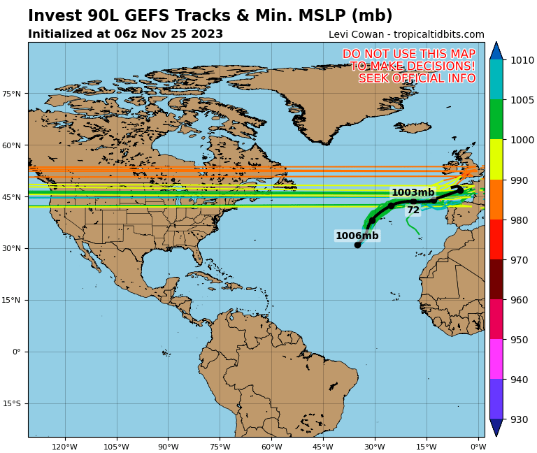
Post by hurricaner on Sept 16, 2020 4:40:07 GMT -6
The system in the SW GOM is now Invest 90L.
An area of low pressure over the southwestern Gulf of Mexico is producing showers and thunderstorms that are showing some signs of organization Upper-level winds are forecast to gradually become more conducive for development, and a tropical depression could form late this week while the low meanders over the southern Gulf of Mexico for the next several days.
* Formation chance through 48 hours...low...20 percent. * Formation chance through 5 days...medium...40 percent.
Last Edit: Sept 22, 2020 17:54:15 GMT -6 by SKYSUMMIT
Post by hurricaner on Sept 16, 2020 5:44:24 GMT -6
Percentages are up again for Invest 90L.
An area of low pressure over the southwestern Gulf of Mexico is producing showers and thunderstorms that have become a little better organized during the past several hours. Upper-level winds are forecast to gradually become more conducive for development, and a tropical depression could form late this week or over the weekend while the low meanders over the southern Gulf of Mexico for the next several days.
* Formation chance through 48 hours...medium...40 percent. * Formation chance through 5 days...medium...60 percent.
Last Edit: Sept 16, 2020 5:45:03 GMT -6 by hurricaner
Post by thibodauxwx on Sept 16, 2020 5:55:18 GMT -6
Just looked at 06z gfs, it looks like it wants to bring it to the North Central Gulf coast this weekend. None of the other models show this. They send it to Mexico it appears.
Post by shompy6411 on Sept 16, 2020 6:01:49 GMT -6
I thought we will have a strong ridge over the central gulf coast starting this weekend and for most of next week with the front coming through. This should protect us from any tropical systems?
Just looked at 06z gfs, it looks like it wants to bring it to the North Central Gulf coast this weekend. None of the other models show this. They send it to Mexico it appears.
It barely has it forming while drifts n as an open wave then goes west into corpus
SKYSUMMIT President | Director of OperationsAdministrator
Just looked at 06z gfs, it looks like it wants to bring it to the North Central Gulf coast this weekend. None of the other models show this. They send it to Mexico it appears.
It keeps it as an open wave however with the vorticity remaining down in the BoC. Then eventually moves the weak vorticity into Texas. We all know how the GFS has been this season though...it doesn't show anything until we actually have a developed storm.
Last Edit: Sept 16, 2020 6:43:02 GMT -6 by SKYSUMMIT
The GFS doesn't do much with it, but brings it's moisture to the northern gulf coast. The Euro, GFS-parallel, and Canadian all form it to one degree or another. Then crashes it into central Mexico. The Icon forms it up a little, then ends the run with it sitting dang near stationary in the middle of the Gulf as either a low or a depression.
Post by Zack Fradella on Sept 16, 2020 6:50:16 GMT -6
Here we go again.
Could we see two circulations develop over the next several days with this area? Possibly. A lot of the ensembles meander it around and the longer it sits, the better the chances something eventually grabs it with a pull to the north.
Everyone is on high alert so you don’t want to scare anyone but this isn’t a storm I’d say oh it’s going into Mexico no worries.
The lady Met on WBRZ just said it’s drifting south into Mexico and will NOT be affecting the US.
I sure hope she didn't get that info from Dr. "Don't Worry No Accumulations as 6.5 inches of wet snow resulted in major power outages for days" Josh Eachus.
I’m dizzy now. Lol! Do you have an updated graphic of the other picture you like to use? I can’t think of what it’s called.... it shows the potential tracks of future storms all over the globe. It’s been a while since you uploaded it.
“On Christ, the solid Rock I stand. Everything else is just sinking sand.”