


Post by SKYSUMMIT on Oct 27, 2021 11:57:51 GMT -6
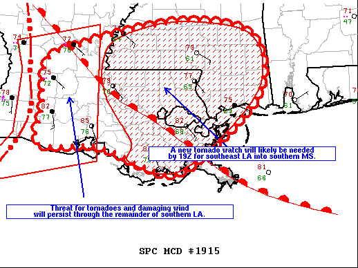
Mesoscale Discussion 1915
NWS Storm Prediction Center Norman OK
1250 PM CDT Wed Oct 27 2021
Areas affected...southern Louisiana through southern Mississippi
Concerning...Tornado Watch 540...
Valid 271750Z - 271915Z
The severe weather threat for Tornado Watch 540 continues.
SUMMARY...Threat for damaging wind and tornadoes including potential
for a couple of strong tornadoes should persist over southern LA,
spreading east through southeast LA and southern MS during the
afternoon. A new tornado watch will likely be needed for this area
by 19Z.
DISCUSSION...A line of storms with embedded bowing segments and some
supercell structures continues moving through western LA at around
35 kt. East of this line the warm sector continues to expand
northward south of a warm front that extends from southeast through
north central LA. A very moist boundary layer is in place south of
this front with mid 70s F dewpoints, and diabatic warming has
boosted surface temperatures into the low to mid 80s F supporting up
to 2000 J/kg MLCAPE. Several northwest-southeast oriented
convergence bands are evident on visible imagery extending into
southern LA from the Gulf. The 18Z RAOB from Slidell modified for
surface conditions in warm sector indicates minimal inhibition. This
suggests that, in addition to the arrival of the line of storms, the
potential will exist for discrete storms develop as the boundary
layer continues to destabilize. The low-level jet is forecast to
undergo further strengthening, supporting large hodographs with 0-1
km storm relative helicity from 250-350 m2/s2. Threat for damaging
wind and tornadoes will persist through the remainder of the
afternoon into early evening in this region.
..Dial/Thompson.. 10/27/2021


