Post by HarahanTim-Now in Gallatin, TN on Aug 5, 2016 8:04:51 GMT -6
TROPICAL WEATHER OUTLOOK NWS NATIONAL HURRICANE CENTER MIAMI FL 800 AM EDT FRI AUG 5 2016
For the North Atlantic...Caribbean Sea and the Gulf of Mexico:
The National Hurricane Center is issuing advisories on Tropical Storm Earl, located over the southern Bay of Campeche.
1. A trough of low pressure is expected to form over the northeastern Gulf of Mexico late in the weekend or early next week. Some subsequent development of this system is possible while it remains nearly stationary. * Formation chance through 48 hours...low...near 0 percent * Formation chance through 5 days...low...20 percent
Buying or Selling Real Estate?--->scottguidry.com United Real Estate Partners - New Orleans / North Shore Scott Guidry, Realtor, ABR, AHWD, AWREP, C2EX Click HERE To Download My FREE MLS Touch App! NWS COOP ID: 16-7425-08 CoCoRaHs ID: LA-TG-23
SKYSUMMIT
Administrator President | Director of Operations
TROPICAL WEATHER OUTLOOK NWS NATIONAL HURRICANE CENTER MIAMI FL 200 PM EDT FRI AUG 5 2016
For the North Atlantic...Caribbean Sea and the Gulf of Mexico:
The National Hurricane Center is issuing advisories on Tropical Storm Earl, located over the southern Bay of Campeche.
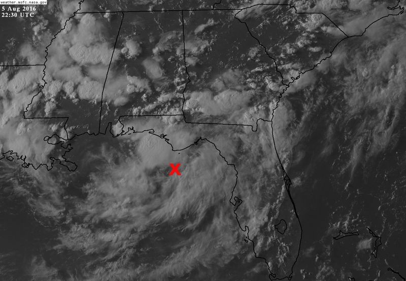
An area of cloudiness and thunderstorms associated with a trough of low pressure is located over the northeastern Gulf of Mexico. Some slow development of this system is possible while it meanders near the coast of the Florida panhandle during the next few days. * Formation chance through 48 hours...low...10 percent * Formation chance through 5 days...low...20 percent
$$ Forecaster Avila
Buying or Selling Real Estate?--->scottguidry.com United Real Estate Partners - New Orleans / North Shore Scott Guidry, Realtor, ABR, AHWD, AWREP, C2EX Click HERE To Download My FREE MLS Touch App! NWS COOP ID: 16-7425-08 CoCoRaHs ID: LA-TG-23
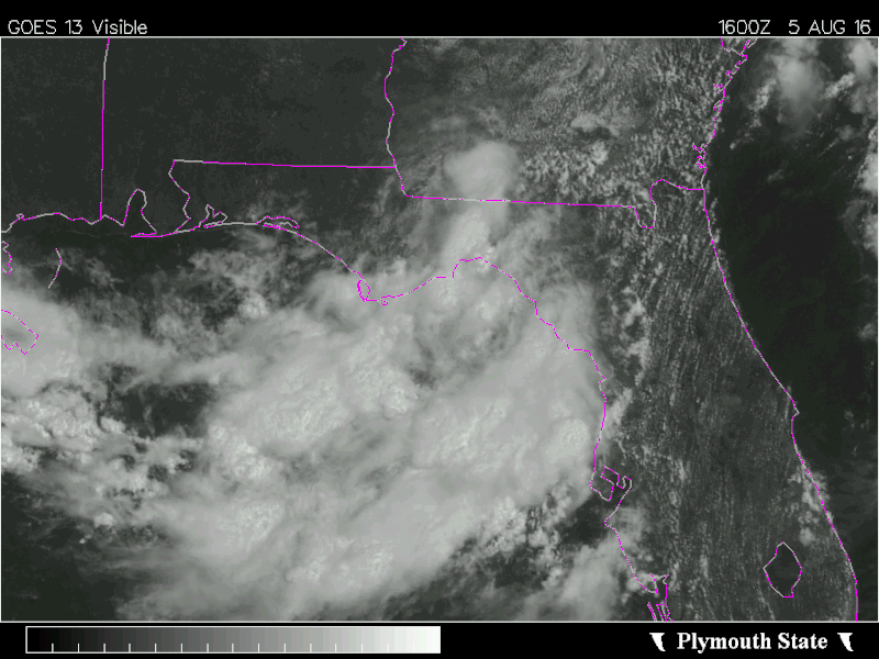
Satellite shows vorticity is elongated but getting better defined this afternoon over the Tallahassee/Apalachee Bay area. UL winds are not bad with developing divergence.
Buying or Selling Real Estate?--->scottguidry.com United Real Estate Partners - New Orleans / North Shore Scott Guidry, Realtor, ABR, AHWD, AWREP, C2EX Click HERE To Download My FREE MLS Touch App! NWS COOP ID: 16-7425-08 CoCoRaHs ID: LA-TG-23
TROPICAL WEATHER OUTLOOK NWS NATIONAL HURRICANE CENTER MIAMI FL 800 PM EDT FRI AUG 5 2016
For the North Atlantic...Caribbean Sea and the Gulf of Mexico:
The National Hurricane Center is issuing advisories on Tropical Storm Earl, located over the extreme southwestern Bay of Campeche. An area of cloudiness and thunderstorms associated with a trough of low pressure is located over the northeastern Gulf of Mexico. Some gradual development of this system is possible while it meanders near the coasts of the eastern Florida panhandle and the northern Florida peninsula during the next few days. * Formation chance through 48 hours...low...20 percent * Formation chance through 5 days...low...30 percent
$$ Forecaster Stewart
Buying or Selling Real Estate?--->scottguidry.com United Real Estate Partners - New Orleans / North Shore Scott Guidry, Realtor, ABR, AHWD, AWREP, C2EX Click HERE To Download My FREE MLS Touch App! NWS COOP ID: 16-7425-08 CoCoRaHs ID: LA-TG-23
Shoutbox
northshoreelise: not on the 12z...
Oct 10, 2024 12:15:21 GMT -6
lencast: Really would appreciate it. Thank you, Lena
Sept 27, 2024 5:20:46 GMT -6
lencast: I am in Jacksonville, and trying to drive back to New Orleans. Does anyone here know if the I-10 is passable in Lake City and Tallahassee.
Sept 27, 2024 5:19:03 GMT -6
tcane: This sure looks like it dies quickly. maybe falling apart before metro New Orleans? Just looking at the lat dozen posts and images here.
Sept 10, 2024 11:26:27 GMT -6
rebekahb-Metairie: Looks like it but I wait for the better trained eyes on the forum to respond.
Sept 9, 2024 18:52:32 GMT -6
SKYSUMMIT: Oh sorry guys! I didn't eve see these new messages down here lol
Jul 26, 2024 13:14:47 GMT -6
jenniqtip: Just as soon as* sry fat finger
Jul 7, 2024 12:53:35 GMT -6
jenniqtip: I donate every year. 😀ju sry as soon as the first area of interest pops up!! I rarely post though so the tag isn’t necessary. Just know I appreciate everything you do!!
Jul 7, 2024 12:53:12 GMT -6
larcat: SKYSUMMIT You can slap one on me
Jul 7, 2024 12:12:03 GMT -6
SKYSUMMIT: Thanks laismyhome ! Also, if there is anyone who has donated that has not been given the Supporter tag, please let us know.
Jul 7, 2024 4:00:50 GMT -6
laismyhome: Here's a friendly reminder to go make a donation to support this forum that is so full of valuable reliable info. Link to donate is on homepage
Jul 2, 2024 9:55:24 GMT -6
Deleted: Ernesto gonna mog hard. I'm voting Alberto, Ernesto, Rafael and Deshawn
Apr 1, 2024 19:15:21 GMT -6
SKYSUMMIT: ShanaBanana Yes...just click the link and then send a PM to either TIgergirl or myself. I can then shoot her a text letting her know and I'll add your supporter tag. THANK YOU!!!!
Sept 23, 2023 16:08:37 GMT -6
ShanaBanana: At the risk of this being a dumb question. In order to donate, do I follow the instructions when I click “donate”, and then message tigergirl? I see people comment here that they donated, so I wasn’t sure if that had changed.
Sept 20, 2023 10:54:40 GMT -6
SKYSUMMIT: Great to have you back!
Sept 11, 2023 12:20:30 GMT -6
virginialee: Hi Skysummit: I was part of this back at the beginning. So happy to be back.
Sept 8, 2023 5:08:12 GMT -6
SKYSUMMIT: Thanks to everyone who has recently donated! If I missed anyone and you still need a Supporter Tag, let me know.
Sept 7, 2023 13:20:10 GMT -6
akeller11: Just donated
Sept 6, 2023 11:11:36 GMT -6
SKYSUMMIT: Thanks guys and gals! You're very much appreciated!
Aug 30, 2023 11:48:38 GMT -6